

This collection provides digital access to a selection of the fire insurance maps published by the Sanborn Map Company held by the Special Collections Department of Raymond H. Fogler Library. Maps found here include those created for Maine communities through the year 1923.
Additional information about the library's Sanborn map collection, including maps for towns not yet digitized and those published after 1923, can be found in the library's online catalog, URSUS.
We wanted to be sure to note that early Sanborn maps of Portland, Maine, have been digitized by our colleagues at the University of Southern Maine and are available through Osher Map Library's online collections. The Library of Congress has made available online maps published prior to 1900, including those for Maine.
For more information about this collection, please contact the Special Collections Department, 5729 Raymond H. Fogler Library, Orono, ME 04469-5729, um.library.spc @ maine.edu or 207.581.1686.
A Note Regarding Rights & Access
Raymond H. Fogler Library is providing access to these materials for educational and research purposes. The maps that have been uploaded to this digital collection were published before 1923, and the library is not aware of any U.S. copyright protection (see Title 17 of the United States Code) or any other restrictions. However, responsibility for making an independent legal assessment and securing necessary permissions for items ultimately rests with those who wish to use them.
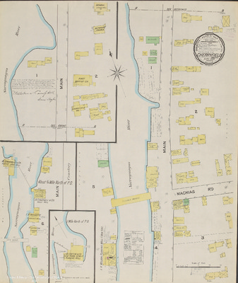
-

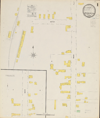
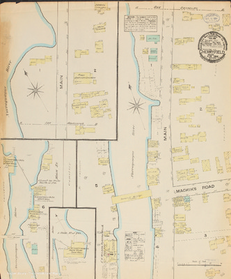
Cherryfield, 1906
Sanborn Map Company
A map of Cherryfield, Maine, at a scale of 1:600 or 50 ft. to an inch. The original color map is 64 x 54 cm.
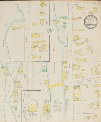
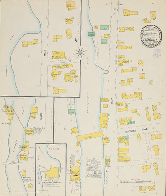
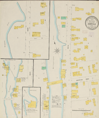
-

Cherryfield, 1911
Sanborn Map Company
Maps of Cherryfield, Maine, at a scale of 1:600 or 50 ft. to an inch. The original color maps are on sheets 64 x 54 cm.
-

Corinna, 1912
Sanborn Map Company
Maps of Corinna, Maine, at a scale of 1:600 or 50 ft. to an inch. The original color maps are on sheets 64 x 54 cm.
-

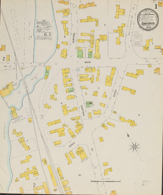
Danforth, 1900
Sanborn-Perris Map Co.
Maps of Danforth, Maine, at a scale of 1:600 or 50 ft. to an inch. The original color maps are on sheets 64 x 54 cm.
-

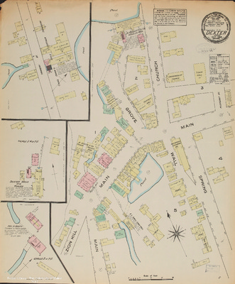
Dexter, 1884
Sanborn Map & Publishing Co.
A map of Dexter, Maine, at a scale of 1:600 or 50 ft. to an inch. The original color map measures 64 x 54 cm.
-

Dexter, 1889
Sanborn-Perris Map Co.
Maps of Dexter, Maine, at a scale of 1:600 or 50 ft. to an inch. The original color maps are on sheets 64 x 54 cm.
-

Dexter, 1894
Sanborn-Perris Map Co.
Maps of Dexter, Maine, at a scale of 1:600 or 50 ft. to an inch. The original color maps are on sheets 64 x 54 cm. Sheet 1 includes an index of the area covered on the remaining sheets.
-

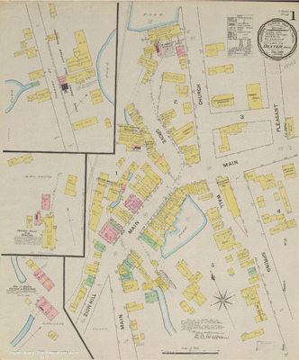
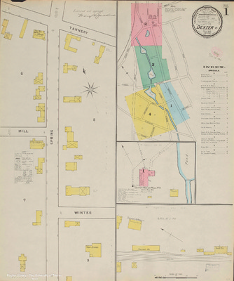
Dexter, 1900
Sanborn-Perris Map Co.
Maps of Dexter, Maine, at a scale of 1:600 or 50 ft. to an inch. The original color maps are on sheets 64 x 54 cm. Sheet 1 includes an index of the area covered on the remaining sheets.
-

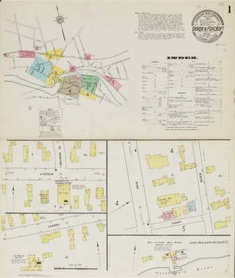
Dover and Foxcroft, 1884
Sanborn Map & Publishing Company
A map covering the areas of Dover and Foxcroft, Maine, at a scale of 1:600 or 50 feet to 1 inch. The original color map, dated October, 1884, is on a sheet 64 x 54 cm.
-

Dover and Foxcroft, 1889
Sanborn-Perris Map Co.
Maps covering the areas of Dover and Foxcroft, Maine, at a scale of 1:600 or 50 feet to 1 inch. The original color maps, dated December, 1889, are on sheets 64 x 54 cm.
-

Dover and Foxcroft, 1894
Sanborn-Perris Map Co.
Maps covering the areas of Dover and Foxcroft, Maine, at a scale of 1:600 or 50 feet to 1 inch. The original color maps, dated November, 1894, are on sheets 64 x 54 cm.
-

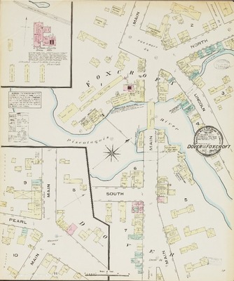
Dover and Foxcroft, 1900
Sanborn-Perris Map Co.
Maps covering the areas of Dover and Foxcroft, Maine, at a scale of 1:600 or 50 feet to 1 inch. The original color maps, dated November, 1900, are on sheets 64 x 54 cm. Sheet 1 includes an index of the area covered on subsequent sheets.
-

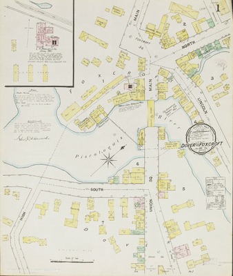
Dover and Foxcroft, 1906
Sanborn Map Company
Maps covering the areas of Dover and Foxcroft, Maine, at a scale of 1:600 or 50 feet to 1 inch. The original color maps are on sheets 64 x 54 cm. Sheet 1 includes an index of the area covered on subsequent sheets.
-

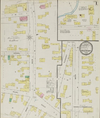
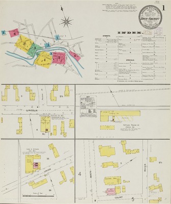
Dover and Foxcroft, 1911
Sanborn Map Company
Maps covering the areas of Dover and Foxcroft, Maine, at a scale of 1:600 or 50 feet to 1 inch. The original color maps are on sheets 64 x 54 cm. Sheet 1 includes an index of the area covered on subsequent sheets.
-

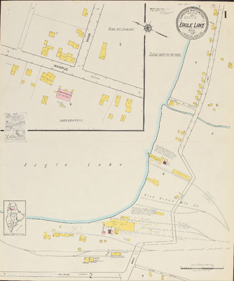
Eagle Lake, 1919
Sanborn Map Company
Maps of Eagle Lake, Maine, at a scale of 1:600 or 50 ft. to an inch. The original color maps are on sheets 64 x 54 cm.
-

East Millinocket, 1916
Sanborn Map Company
Maps of East Millinocket, Maine, at a scale of 1:600 or 50 ft. to an inch. The original color maps are on sheets 64 x 54 cm.
-

Easton and Spragues Mills, 1895
Sanborn-Perris Map Co.
A map of Easton and Spragues Mills, Maine, at a scale of 1:600 or 50 ft. to an inch. The original color map is 64 x 54 cm.
-

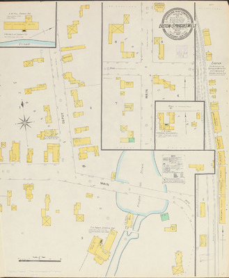
Easton and Spragues Mills, 1903
Sanborn Map Company
A map of Easton and Spragues Mills, Maine, at a scale of 1:600 or 50 ft. to an inch. The original color map is 64 x 54 cm.
-

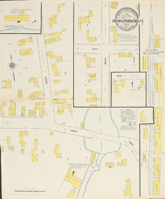
Easton and Spragues Mills, 1911
Sanborn Map Company
A map of Easton and Spragues Mills, Maine, at a scale of 1:600 or 50 ft. to an inch. The original color map is 64 x 54 cm.
-

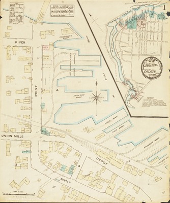
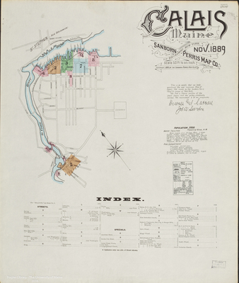
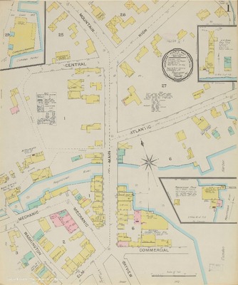
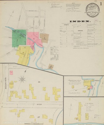
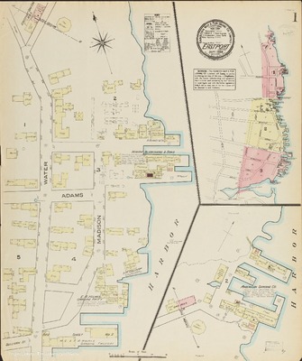
Eastport, 1884
Sanborn Map & Publishing Co
Maps of Eastport, Maine, at a scale of 1:600 or 50 feet to an inch. The original color maps are on sheets 64 x 54 cm.
-

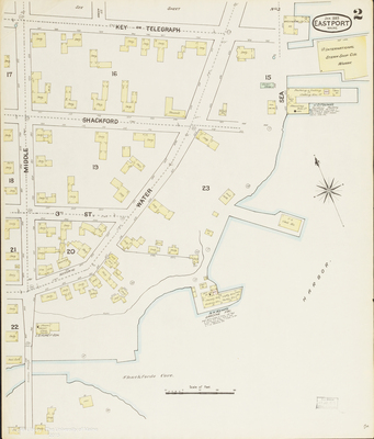
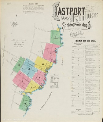
Eastport, 1889
Sanborn Map Company & Publishing Company
Maps of Eastport, Maine, at a scale of 1:600 or 50 feet to 1 inch. Sheet one is dated December, 1888, but the rest of the maps in the set are dated 1889. The original color maps are on sheets 64 x 54 cm. Sheet 1 includes an index of the area covered on the remaining sheets.
-

Eastport and Lubec, 1893
Sanborn Map Company
Maps of Eastport & Lubec, Maine,at a scale of 1:600 or 50 feet to 1 inch. The original color maps are on sheets 64 x 54 cm. Sheet 1 includes an index of the area covered on subsequent sheets.
-

Eastport and Lubec, 1898
Sanborn Map Company
Maps of Eastport and Lubec, Maine, at a scale of 1:600 or 50 feet to 1 inch. The original color maps are on sheets 64 x 54 cm. Sheet 1 includes an index of the area covered on subsequent sheets.
-

Eastport and Lubec, 1903
Sanborn Map Company
Maps of Eastport and Lubec, Maine, at a scale of 1:600 or 50 feet to 1 inch. The original color maps are on sheets 64 x 54 cm. Sheet 1 includes an index of the area covered on subsequent sheets.
-

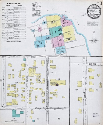
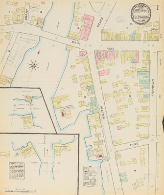
Ellsworth, 1884
Sanborn Map & Publishing Co.
Maps of Ellsworth, Maine, at a scale of 1:600 or 50 ft. to an inch. The original color maps are on sheets 64 x 54 cm.
-

Ellsworth, 1889
Sanborn-Perris Map Co.
Maps of Ellsworth, Maine, at a scale of 1:600 or 50 ft. to an inch. The original color maps are on sheets 64 x 54 cm. Sheet 1 includes an index of the area covered on the remaining sheets.
-

Ellsworth, 1895
Sanborn-Perris Map Co.
Maps of Ellsworth, Maine, at a scale of 1:600 or 50 ft. to an inch. The original color maps are on sheets 64 x 54 cm. Sheet 1 includes an index of the area covered on the remaining sheets.
-

Ellsworth, 1901
Sanborn-Perris Map Co.
Maps of Ellsworth, Maine, at a scale of 1:600 or 50 ft. to an inch. The original color maps are on sheets 64 x 54 cm. Sheet 1 includes an index of the area covered on the remaining sheets.
-

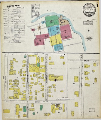
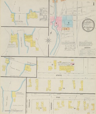
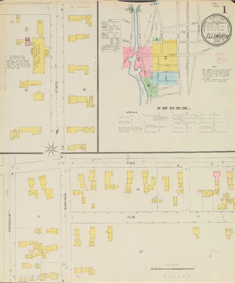
Ellsworth, 1907
Sanborn Map Company
Maps of Ellsworth, Maine, at a scale of 1:600 or 50 ft. to an inch. The original color maps are on sheets 64 x 54 cm. Sheet 1 includes an index of the area covered on the remaining sheets.
-

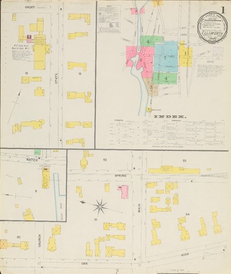
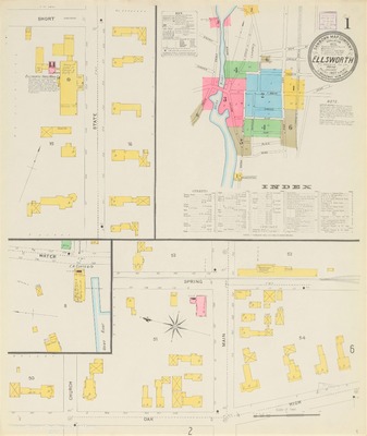
Ellsworth, 1914
Sanborn Map Company
Maps of Ellsworth, Maine, at a scale of 1:600 or 50 ft. to an inch. The original color maps are on sheets 64 x 54 cm. Sheet 1 includes an index of the area covered on the remaining sheets.
-

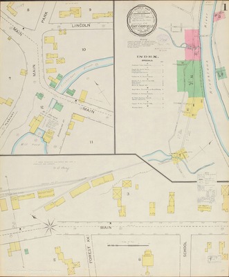
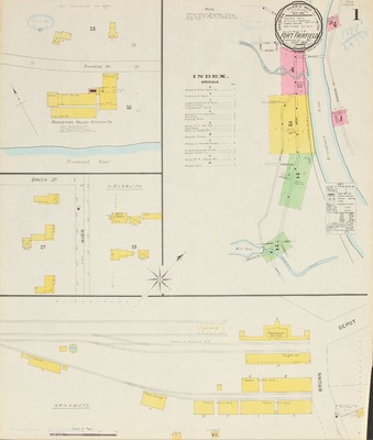
Fort Fairfield, 1893
Sanborn-Perris Map Co.
Maps of Fort Fairfield, Maine, at a scale of 1:600 or 50 ft. to an inch. The original color maps are on sheets 64 x 54 cm. Sheet 1 includes an index of the area covered on the remaining sheets.
-

Fort Fairfield, 1898
Sanborn-Perris Map Co.
Maps of Fort Fairfield, Maine, at a scale of 1:600 or 50 ft. to an inch. The original color maps are on sheets 64 x 54 cm. Sheet 1 includes an index of the area covered on the remaining sheets.
-

Fort Fairfield, 1903
Sanborn Map Company
Maps of Fort Fairfield, Maine, at a scale of 1:600 or 50 ft. to an inch. The original color maps are on sheets 64 x 54 cm. Sheet 1 includes an index of the area covered on the remaining sheets.
-

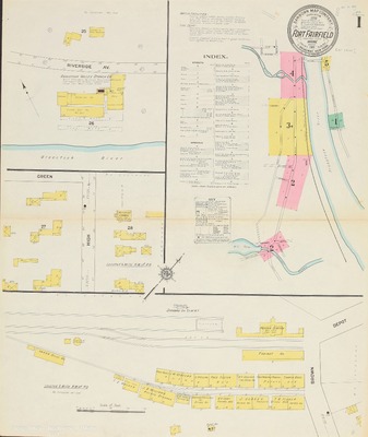
Fort Fairfield, 1911
Sanborn Map Company
Maps of Fort Fairfield, Maine, at a scale of 1:600 or 50 ft. to an inch. The original color maps are on sheets 64 x 54 cm. Sheet 1 includes an index of the area covered on the remaining sheets.
-

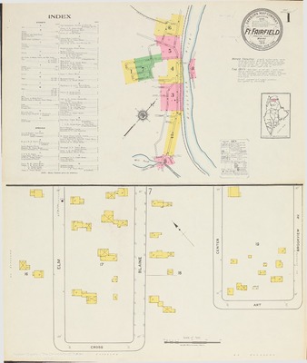
Fort Fairfield, 1919
Sanborn Map Company
Maps of Fort Fairfield, Maine, at a scale of 1:600 or 50 ft. to an inch. The original color maps are on sheets 64 x 54 cm. Sheet 1 includes an index of the area covered on the remaining sheets.
-

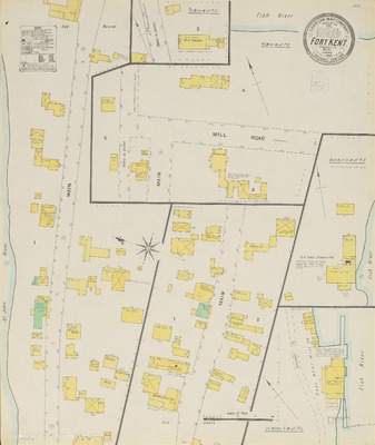
Fort Kent, 1904
Sanborn Map Company
Map of Fort Kent, Maine, at a scale of 1:600 or 50 ft. to an inch. The original color map is on a sheet 64 x 54 cm.
-

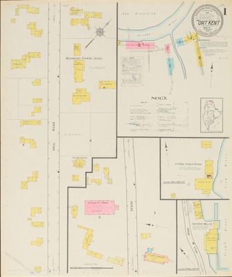
Fort Kent, 1912
Sanborn Map Company
Maps of Fort Kent, Maine, at a scale of 1:600 or 50 ft. to an inch. The original color maps are on sheets 64 x 54 cm. Sheet 1 includes an index of the area covered on the remaining sheets.
-

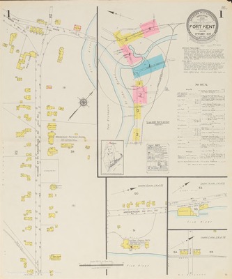
Fort Kent, 1917
Sanborn Map Company
Maps of Fort Kent, Maine, at a scale of 1:600 or 50 ft. to an inch. The original color maps are on sheets 64 x 54 cm. Sheet 1 includes an index of the area covered on the remaining sheets.
-

Fort Kent, 1926
Sanborn Map Company
Maps of Fort Kent, Maine, at a scale of 1:600 or 50 ft. to an inch. The original color maps are on sheets 64 x 54 cm. Sheet 1 includes an index of the area covered on the remaining sheets.
-

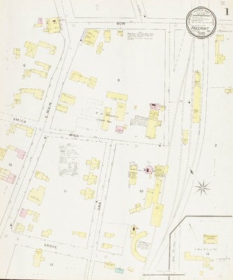
Freeport, 1894
Sanborn-Perris Map Co.
Maps of Freeport, Maine, at a scale of 1:600 or 50 ft. to an inch. The original color maps are on sheets 64 x 54 cm.
-

Freeport, 1901
Sanborn-Perris Map Co.
Maps of Freeport, Maine, at a scale of 1:600 or 50 ft. to an inch. The original color maps are on sheets 64 x 54 cm.
-

Freeport, 1906
Sanborn Map Company
Maps of Freeport, Maine, at a scale of 1:600 or 50 ft. to an inch. The original color maps are on sheets 64 x 54 cm.
-

Freeport, 1912
Sanborn Map Company
Maps of Freeport, Maine, at a scale of 1:600 or 50 ft. to an inch. The original color maps are on sheets 64 x 54 cm. Sheet 1 includes an index of the area covered on subsequent sheets.
-

Freeport, 1923
Sanborn Map Company
Maps of Freeport, Maine, at a scale of 1:600 or 50 ft. to an inch. The original color maps are on sheets 64 x 54 cm. Sheet 1 includes an overview of areas covered on the remaining sheets.
-

Frenchville, 1917
Sanborn Map Company
A map of Frenchville, Maine, at a scale of 1:600 or 50 ft. to an inch. The original color map is 64 x 54 cm.
-

Greenville, 1904
Sanborn Map Company
Maps of Greenville, Maine, at a scale of 1:600 or 50 ft. to an inch. The original color maps are on sheets 64 x 54 cm. Sheet 1 includes an index of the area covered on the remaining sheets.
-

Greenville, 1911
Sanborn Map Company
Maps of Greenville, Maine, at a scale of 1:600 or 50 ft. to an inch. The original color maps are on sheets 64 x 54 cm. Sheet 1 includes an index of the area covered on the remaining sheets.
-

Greenville, 1927
Sanborn Map Company
Maps of Greenville, Maine, at a scale of 1:600 or 50 ft. to an inch. The original color maps are on sheets 64 x 54 cm. Sheet 1 includes an index of the area covered on the remaining sheets.
-

Guilford, 1889
Sanborn-Perris Map Co.
A map of Guilford, Maine, at a scale of 1:600 or 50 ft. to an inch. The original color map is 64 x 54 cm.
-

Guilford, 1894
Sanborn-Perris Map Co.
A map of Guilford, Maine, at a scale of 1:600 or 50 ft. to an inch. The original color map is 64 x 54 cm.
-

Guilford, 1900
Sanborn-Perris Map Co.
Maps of Guilford, Maine, at a scale of 1:600 or 50 ft. to an inch. The original color maps are on sheets 64 x 54 cm.
-

Guilford, 1906
Sanborn Map Company
Maps of Guilford, Maine, at a scale of 1:600 or 50 ft. to an inch. The original color maps are on sheets 64 x 54 cm. Sheet 1 includes an index of the area covered on the remaining sheets.
-

Guilford, 1911
Sanborn Map Company
Maps of Guilford, Maine, at a scale of 1:600 or 50 ft. to an inch. The original color maps are on sheets 64 x 54 cm. Sheet 1 includes an index of the area covered on the remaining sheets.
-

Houlton, 1884
Sanborn Map & Publishing Co.
Maps of Houlton, Maine, at a scale of 1:600 or 50 ft. to an inch. The original color maps are on sheets 64 x 54 cm. Sheet 1 includes an index of the area covered on both sheets.
-

Houlton, 1889
Sanborn-Perris Map Co.
Maps of Houlton, Maine, at a scale of 1:600 or 50 ft. to an inch. The original color maps are on sheets 64 x 54 cm. Sheet 1 includes an index of the area covered on the remaining sheets.
-

Houlton, 1894
Sanborn-Perris Map Co.
Maps of Houlton, Maine, at a scale of 1:600 or 50 ft. to an inch. The original color maps are on sheets 64 x 54 cm. Sheet 1 includes an index of the area covered on the remaining sheets.
-

Houlton, 1900
Sanborn-Perris Map Co.
Maps of Houlton, Maine, at a scale of 1:600 or 50 ft. to an inch. The original color maps are on sheets 64 x 54 cm. Sheet 1 includes an index of the area covered on the remaining sheets.
-

Houlton, 1906
Sanborn Map Company
Maps of Houlton, Maine, at a scale of 1:600 or 50 ft. to an inch. The original color maps are on sheets 64 x 54 cm. Sheet 1 includes an index of the area covered on the remaining sheets.
-

Houlton, 1912
Sanborn Map Company
Maps of Houlton, Maine, at a scale of 1:600 or 50 ft. to an inch. The original color maps are on sheets 64 x 54 cm. Sheet 1 includes an index of the area covered on the remaining sheets.
-

Houlton, 1919
Sanborn Map Company
Maps of Houlton, Maine, at a scale of 1:600 or 50 ft. to an inch. The original color maps are on sheets 64 x 54 cm. Sheet 1 includes an index of the area covered on the remaining sheets.