

Files
Download Sheet 1 and Index as a .pdf file (1.2 MB)
Download Eastport and Lubec, 1893, Sheet 1 (6.0 MB)
Download Eastport and Lubec, 1893, Sheet 2 (5.5 MB)
Download Eastport and Lubec, 1893, Sheet 3 (6.0 MB)
Download Eastport and Lubec, 1893, Sheet 4 (5.8 MB)
Download Eastport and Lubec, 1893, Sheet 5 (5.9 MB)
Download Eastport and Lubec, 1893, Sheet 6 (5.6 MB)
Download Eastport and Lubec, 1893, Sheet 7 (5.5 MB)
Download Eastport and Lubec, 1893, Sheet 8 (5.4 MB)
Download Eastport and Lubec, 1893, Sheet 9 (5.6 MB)
Download Eastport and Lubec, 1893, Sheet 10 (5.5 MB)
Download Eastport and Lubec, 1893, Sheet 11 (5.4 MB)
Download Eastport and Lubec, 1893, Sheet 12 (5.3 MB)
Download Eastport and Lubec, 1893, Sheet 13 (5.5 MB)
Description
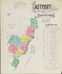
Maps of Eastport & Lubec, Maine,at a scale of 1:600 or 50 feet to 1 inch. The original color maps are on sheets 64 x 54 cm. Sheet 1 includes an index of the area covered on subsequent sheets.
Publication Date
1893
Rights and Access Note
Raymond H. Fogler Library is providing access to these materials for educational and research purposes. Rights assessment remains the responsibility of the researcher. No known restrictions on publication.
Publisher
Sanborn Map Company
City
New York
Keywords
maps, fire insurance, Eastport, Lubec, Maine, Washington County
Disciplines
Geography | History
Recommended Citation
Sanborn Map Company, "Eastport and Lubec, 1893" (1893). Sanborn Maps of Maine. 18.
https://digitalcommons.library.umaine.edu/me_sanbornmaps/18
Rights Statement
