

Description
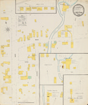
A map of Limestone, Maine, at a scale of 1:600 or 50 ft. to an inch. The original color map is 64 x 54 cm. Businesses that appear on the map include W. I. Getchell's Saw Mill, J. M. Noyes Saw Mill, McKeever & Hall Potato House, W. B. Ward Potato House, Nelson & Clark Potato House, the Bowker Fertilizer Store House, R. B. Levett Potato House, S. B. Durepo Potato House and the T. H. Phair Starch Factory.
Publication Date
10-1900
Rights and Access Note
Raymond H. Fogler Library is providing access to these materials for educational and research purposes. Rights assessment remains the responsibility of the researcher. No known restrictions on publication.
Publisher
Sanborn-Perris Map Company
City
New York
Keywords
maps, fire insurance, buildings, downtown, Limestone, Aroostook County, Maine
Disciplines
Geography | History
Recommended Citation
Sanborn-Perris Map Co., Limited, "Limestone, 1900" (1900). Sanborn Maps of Maine. 231.
https://digitalcommons.library.umaine.edu/me_sanbornmaps/231
Rights Statement
