

Files
Description
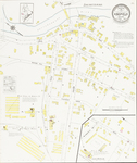
Map of Kingfield, Maine, at a scale of 1:1200 or 100 ft to 1 inch. The original color map is 64 x 54 cm. Map includes the area of downtown along the Carrabassett River and shows the locations of the Wing Spool and Bobbin Company, Jenkins and Bogert Manufacturing Company's Novelty Wood Turning Works, and the Roy C. Huse Bull Spool and Bobbin Mill.
Publication Date
1923
Rights and Access Note
Raymond H. Fogler Library is providing access to these materials for educational and research purposes. Rights assessment remains the responsibility of the researcher. No known restrictions on publication.
Publisher
Sanborn Map Company
City
New York
Keywords
maps, fire insurance, downtowns, industry, manufacturing, mills, buildings, Kingfield, Maine, Franklin County
Disciplines
Geography | History
Recommended Citation
Sanborn Map Company, "Kingfield, 1923" (1923). Sanborn Maps of Maine. 15.
https://digitalcommons.library.umaine.edu/me_sanbornmaps/15
Rights Statement
