


Files
Description
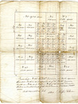
Township N.38 Middle Division, six miles square bounded North on unlocated lands of the North Division, South on N.32 and East on N.39 of the Middle Division; West on unlocated lands of the First Division. Contains 23,040 acres. Scale 200 rods to an inch (or 1:396). Attest Rufus Putnam
On the back of the map, there is a list of proprietor names, the number of lots, acres in each lot and "number of the tickets drawn against."
Rights and Access Note
Rights assessment remains the responsibility of the researcher. No known restrictions on publication. For information about the process and fees for obtaining higher resolution scans or another file format, contact Special Collections.
Publication Date
9999
Keywords
Maine Maps, Washington County Maine, Historic Maps, Regional Maps
Disciplines
United States History
Recommended Citation
Putnam, Rufus, "No. 38 Middle Division #53, Washington County, Maine" (9999). Maine Bicentennial. 68.
https://digitalcommons.library.umaine.edu/mainebicentennial/68
Included in
Rights Statement

Comments
SpC_MS_0784_Folder51A_Item10