


Description
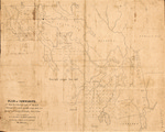
Undated, printed map of townships in Washington County, Maine, made from surveys by R. N. Hayden and John Gardner. The map includes 92,160 acres, exclusive of Native American holdings. The map label reads: "Plan of Townships. Nos. 21 & 27 E.D. East half. No. 43 M.D. No. 6 & N. half No. 5 with two mile strips north, N.D. Situated in County of Washington, State of Maine." The map scale is 1:63,360, or one inch to a mile.
Rights and Access Note
Rights assessment remains the responsibility of the researcher. No known restrictions on publication. For information about the process and fees for obtaining higher resolution scans or another file format, contact Special Collections.
Publication Date
9999
Keywords
Maine Maps, New England Maps, Historic Maps, Regional Maps
Disciplines
Geography | United States History
Recommended Citation
Hayden, Richard N. and Gardner, John, "Plan of Townships. Nos. 21 & 27 E.D. East Half No. 43 M.D. No. 6 & N. Half No. 5 with the Two Mile Strips North, N.D. Situated in the County of Washington, State of Maine" (9999). Maine Bicentennial. 46.
https://digitalcommons.library.umaine.edu/mainebicentennial/46
Included in
Rights Statement

Comments
SpC_MS_0784_Mapdrawer_Folder51_Item9