


Description
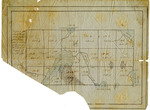
Hand-drawn pen and ink map on blue paper identified by the caption: "A plan of the South half No. 5 North division on a scale of 160 Rods to an inch [1:11,880], County of Washington." The rectangular map is six lots wide and three lots deep and includes depiction of numbered lots with the acreage noted. Bodies of water are shaded with blue pencil. The lower left corner of the map has been torn away.
Rights and Access Note
Rights assessment remains the responsibility of the researcher. No known restrictions on publication. For information about the process and fees for obtaining higher resolution scans or another file format, contact Special Collections.
Publication Date
9999
Keywords
Maine Maps, Washington County Maine, Historic Maps, Regional Maps
Disciplines
United States History
Recommended Citation
Gardner, Benjamin, "A Plan of the South Half Township No. 5 North Division ... County of Washington" (9999). Maine Bicentennial. 60.
https://digitalcommons.library.umaine.edu/mainebicentennial/60
Included in
Rights Statement

Comments
SpC_MS_0784_Folder51A_Item6