


Description
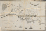
Black and white by William Willis in 1831, depicting Falmouth Neck (present day Portland) as it appeared prior to the October 18, 1775 bombardment by the British Navy under the command of Captain Henry Mowat (1734-1798). Willis includes the caption: "All the buildings within the Dotted line were destroyed except a few within the perfect line." British ships depicted in the etching include the 16-gun HMS Canceau[sic], the 20-gun Cat, the bomb sloop HMS Spitfire, and the HMS Symmetry labeled "store vessel." The unlabeled ship may be the 12-gun schooner HMS Halifax. Mowat was under orders from Vice-Admiral Samuel Graves to "lay waste burn and destroy such Sea Port towns as are accessible to His Majesty's ships..." Map provides a scale of rods and a compass arrow indicating north. Scale: 1:1,238 Map size: 41 x 60 cm. Map is stable but fragile and shows evidence of foxing and repairs from previous tears.
Rights and Access Note
Rights assessment remains the responsibility of the researcher. No known restrictions on publication. For information about the process and fees for obtaining higher resolution scans or another file format, contact Special Collections.
Publication Date
1831
Publisher
Pendleton's Lithography
City
Boston
Keywords
Maine Maps, New England Maps, Historic Maps, American Revolution
Disciplines
United States History
Recommended Citation
Willis, William, "Falmouth Neck as it was when destroyed by Mowett, Oct. 18, 1775" (1831). Maine Bicentennial. 29.
https://digitalcommons.library.umaine.edu/mainebicentennial/29
Included in
Rights Statement

Comments
MaineMap220