


Description
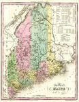
Hand-colored map of Maine by H. S. Tanner from Tanner's Universal Atlas, p. 5. Caption includes "Entered according to Act of Congress in the year 1833 by H. S. Tanner in the Clerks Office of the Eastern District Pennsylvania." Scale: 1:3,168,000. Map size: 36 x 28 cm. Scale of miles appears at the bottom of the page. Map includes an accounting of county populations in the years of 1820 and 1830. Map includes a key for roads.
Rights and Access Note
Rights assessment remains the responsibility of the researcher. No known restrictions on publication. For information about the process and fees for obtaining higher resolution scans or another file format, contact Special Collections.
Publication Date
1833
City
Philadelphia
Keywords
Maine Maps, New England Maps, Historic Maps, Regional Maps
Disciplines
United States History
Recommended Citation
Tanner, Henry Schenck, "A New Map of Maine by H.S. Tanner" (1833). Maine Bicentennial. 27.
https://digitalcommons.library.umaine.edu/mainebicentennial/27
Included in
Rights Statement

Comments
MaineMap500