


Description
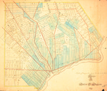
Hand-drawn and tinted property map for the city of Bangor. Some lots include property owner names. Maine roads depicted in red. Map size: 55 x 65 cm. Map is stable but shows signs of foxing and yellowing.
Rights and Access Note
Rights assessment remains the responsibility of the researcher. No known restrictions on publication. For information about the process and fees for obtaining higher resolution scans or another file format, contact Special Collections.
Publication Date
1840
Keywords
Maine Maps, New England Maps, Historic Maps, Regional Maps
Disciplines
United States History
Recommended Citation
Gilmore, Charles D., "A Plan of Bangor, County of Penobscot & State of Maine" (1840). Maine Bicentennial. 25.
https://digitalcommons.library.umaine.edu/mainebicentennial/25
Included in
Rights Statement

Comments
MaineMap1171