


Description
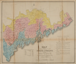
Map of the inhabited part of the state of Maine : exhibiting the progress of its settlement since the year 1778, the Representative Districts since the year 1820, and the population and valuation of taxable property in each district at the year 1820 by Moses Greenleaf. Engraved by William Chapin, N.Y., for Greenleaf's survey of Maine 1828. Published by Shirley & Hyde, Portland, 1829. From Atlas accompanying Greenleaf's map and statistical survey of Maine "Plate VI." Also shows center of taxable property and population for 1778, 1790 and 1820 with geographical center of state, etc.
Hand-colored map of Maine following statehood. Map Size: 48 x 57 cm Scale: 1:560,000. Map includes a scale of miles. Map is in fragile condition showing tears and separations along creases and folds. Sheet includes text notations for population and value of taxable property not represented within the map.
Map sections are designated by color and line patterns. The key to line patterns includes the following information:
The irregular curved line [illustrated example of a line of open circles and dashes] beginning at Freyburgh and terminating at Machias, describes the Northern limits of the settlements at the commencement of the revolution, except a few detached settlements higher up the Kennebeck and Androscoggin.
The line [illustrated example of crosses and solid dots] beginning at Gilead and terminating in No. 7 above Baring, describes the Northern limit of the settlements in the year 1800.
The line [illustrated example of connected crosses and dashes] beginning above Andover and terminating above No. 7, on the Schoodiac describes the Northern limit of the settlements in the year 1820, except the few at Houlton and New Limerick, and the settlement at Madawaska.
The strait [sic] and rectangular lines [illustration of dotted, lightening-shaped line] Northward of the settlements, describe the Northern limit of all the lands taxed for the support of Government, except the plantation of Houlton.
The strait [sic] lines [illustration of a solid, straight line] including one or more towns, are the limits of the respective Representative Districts, except where towns not adjoining each other are united to form a District.
The figures in each District exhibit the population and valuation of that District in the year 1820; — the upper figures being the number of inhabitants and the lower figures the value, in Dollars, of the total real and personal estates subject by law to taxation.
Rights and Access Note
Rights assessment remains the responsibility of the researcher. No known restrictions on publication. For information about the process and fees for obtaining higher resolution scans or another file format, contact Special Collections.
Publication Date
1829
Publisher
Shirley & Hyde
City
Portland, Maine
Keywords
Maine Maps, New England Maps, Historic Maps, Regional Maps
Disciplines
Geography | United States History
Recommended Citation
Greenleaf, Moses, "Map of the Inhabited Part of the State of Maine : Exhibiting the Progress of its Settlement since the Year 1778, the Representative Districts since the Year 1820, and the Population and Valuation of Taxable Property in Each District at the Year 1820" (1829). Maine Bicentennial. 21.
https://digitalcommons.library.umaine.edu/mainebicentennial/21
Included in
Rights Statement

Comments
MaineMap231