


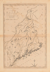
Description
The Province of Maine, from the best Authorities by Samuel Lewis, 1794. W. Barker, sculp. [Scale of] American Miles 69 1/2 to a Degree. Engraved for Carey's American Edition of Guthrie's Geography improved.
Black and white, foldout map of northern Massachusetts showing the New Hampshire border and identifies the "Line between the United States and the British Possessions by Treaty 1785" including Quebec and Nova Scotia. Map size: 36 x 24 cm. Scale 1:1,520,640. Engraved by W. Barker. Map is in stable condition but shows folds and creases.
Rights and Access Note
Rights assessment remains the responsibility of the researcher. No known restrictions on publication. For information about the process and fees for obtaining higher resolution scans or another file format, contact Special Collections.
Publication Date
1794
Publisher
Mathew Carey
City
Philadelphia
Keywords
Maine Maps, New England Maps, Historic Maps, Regional Maps
Disciplines
Geography | United States History
Recommended Citation
Lewis, Samuel; Barker, William; and Carey, Mathew, "The Province of Maine from the Best Authorities" (1794). Maine Bicentennial. 15.
https://digitalcommons.library.umaine.edu/mainebicentennial/15
Included in
Rights Statement

Comments
Lewis, Samuel, 1753 or 1754-1822;
Barker, W. (William), active 1795-1803;
Carey, Mathew, 1760-1839