


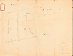
Description
Pen and ink, hand-drawn map of Blue Hill Academy property containing 12,320 acres. Map includes a survey of tree species and landscape features along one of the property boundaries. The map is faded and includes lightly penciled notes and additions. A red-bordered contact adhesive sticker on the face of the map reads: "T.ship 1." Virso is marked "Tship 24." The map does not include a scale.
Key
b — Burnt land
h — Heath
S — Sedar [sic] swamp
g — hardwood stand
v — Rocky land
l — Ledgy land
m — Meadow land
p — Pine
sp — Spruce
J — hackmatack
Rights and Access Note
Rights assessment remains the responsibility of the researcher. No known restrictions on publication. For information about the process and fees for obtaining higher resolution scans or another file format, contact Special Collections.
Publication Date
9999
City
Washington County, Maine
Keywords
Maine Maps, Washington County Maine, Historic Maps, Regional Maps
Disciplines
Geography | United States History
Recommended Citation
Gardner, John, "Blue Hill Academy Lot, Washington County" (9999). Maine Bicentennial. 62.
https://digitalcommons.library.umaine.edu/mainebicentennial/62
Included in
Rights Statement

Comments
SpC_MS_0784_Folder51A_Item2