


Description
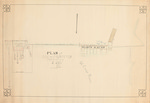
Pen and ink plan of the dam on the St. Croix River in Princeton township drawn on vellum signed by J. W. Edgerly. The plan includes a diagram of Mercier Mill, including the placement and size of the equipment including the shingle, lath machine, edger, rotary saw, and plane. The plan is drawn on a scale of 15 feet to an inch or 1:180. The only date on the plan is a measurement of the depth of water at the sluice gates near the fish way on April 13, 1894.
Rights and Access Note
Rights assessment remains the responsibility of the researcher. No known restrictions on publication. For information about the process and fees for obtaining higher resolution scans or another file format, contact Special Collections.
Publication Date
1894
Keywords
Maine Maps, New England Maps, Historic Maps, Regional Maps
Disciplines
United States History
Recommended Citation
Edgerly, J. W. Jr., "Plan of Dam at Princeton" (1894). Maine Bicentennial. 56.
https://digitalcommons.library.umaine.edu/mainebicentennial/56
Included in
Rights Statement

Comments
SpC_MS_0784_folder_43_map04