


Description
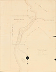
Pen and ink map on vellum of Lewy Lake and Lewy Island in Princeton Indian Township drawn by John Gardner and dated December 16, 1840. The map depicts Putnam Rolfe lands and the location of the proposed dam at the northeast end of Lewy Island.
Rights and Access Note
Rights assessment remains the responsibility of the researcher. No known restrictions on publication. For information about the process and fees for obtaining higher resolution scans or another file format, contact Special Collections.
Publication Date
12-16-1840
Keywords
Maine Maps, Washington County Maine, Historic Maps, Regional Maps
Disciplines
United States History
Recommended Citation
Gardner, John, "Princeton Indian Township and Putnam Rolfe Land" (1840). Maine Bicentennial. 54.
https://digitalcommons.library.umaine.edu/mainebicentennial/54
Included in
Rights Statement

Comments
SpC_MS_0784_folder_44_map04