


Description
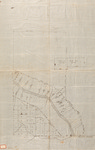
Undated, hand-drawn map in pen and ink on vellum. Map has no recorded title, date or scale. A red bordered adhesive stamp is labeled T.ship 3 in pencil. A faded pencil inscription at the bottom of the map is illegible. Lovely Brook is identified as laying south of the identified "South Line of the Plymouth Township," but a larger river bisecting the land block is unidentified. The creator of the map is not identified but the document is part of the collection belonging to John Gardner.
Rights and Access Note
Rights assessment remains the responsibility of the researcher. No known restrictions on publication. For information about the process and fees for obtaining higher resolution scans or another file format, contact Special Collections.
Publication Date
9999
Keywords
Maine Maps, New England Maps, Historic Maps, Regional Maps
Disciplines
Geography | United States History
Recommended Citation
Gardner, John, "Undated Lot Survey Bordering South Line of Plymouth Township" (9999). Maine Bicentennial. 44.
https://digitalcommons.library.umaine.edu/mainebicentennial/44
Included in
Rights Statement

Comments
SpC_MS_0784_Mapdrawer_Folder51_Item21