


Description
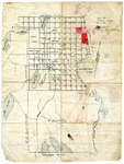
Property map with no scale, showing numbered lots in the Alexander and the town of Cooper. The map indicates eastern boundaries with Township No. 19 and Crawford, Plantation No. 14, and Princeton, Maine. The property was once part of the lands first surveyed Rufus Putnam.
From Gardner Family Papers, 1830-1939. John Gardner (1801-1888), was the principal surveyor in Calais, Maine. His son, Benjamin E. Gardner (1869-1939), a civil engineer and land surveyor took over for his father and worked most frequently with local attorneys doing land title research.
Rights and Access Note
Rights assessment remains the responsibility of the researcher. No known restrictions on publication. For information about the process and fees for obtaining higher resolution scans or another file format, contact Special Collections.
Publication Date
1922
Keywords
Maine Maps, Washington County, Historic Maps, Maine Property Maps, Tax Maps
Disciplines
Geography | United States History
Recommended Citation
Gardner, Benjamin E. and Gardner, John, "Bingham Lands in Alexander and Cooper" (1922). Maine Bicentennial. 37.
https://digitalcommons.library.umaine.edu/mainebicentennial/37
Included in
Rights Statement

Comments
MS_0784_mapdrawer_folder1_item001