


Description
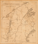
Black and white map of the country which was the scene of operations of the Northern Army; including the wilderness through which General Arnold marched to attack Quebec. Engraved for the Life of Washington. Plate VI from: Atlas to accompany John Marshall's The life of George Washington. Philadelphia, 1804-07. Though this map depicts the route of the Kennebec River and landscape through which Benedict Arnold lead a force of the Continental Army, it does not mark the 350 mile trail to Quebec. The 1,100 man force was reduced to 600 sick and starving men by the time Arnold reached Saint Lawrence at Pointe-Levi. Scale: 1:1,394,000. Map size: 27 x 23 cm. Map is in good and stable condition though considerably yellowed.
Rights and Access Note
Rights assessment remains the responsibility of the researcher. No known restrictions on publication. For information about the process and fees for obtaining higher resolution scans or another file format, contact Special Collections.
Publication Date
1807
Publisher
C. P. Wayne
City
Philadelphia
Keywords
Maine Maps, New England Maps, Historic Maps, American Revolution
Disciplines
United States History
Recommended Citation
Shallus, Francis, "Map of the Country which was the Scene of Operations of the Northern Army ; Including the Wilderness through which General Arnold Marched to Attack" (1807). Maine Bicentennial. 28.
https://digitalcommons.library.umaine.edu/mainebicentennial/28
Included in
Rights Statement

Comments
MaineMap221