


Description
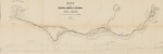
Map of the Bangor, Orono & Oldtown Rail-Road. Surveyed under the direction of A. C. Morton. by A. P. Robinson, Civil Engineer. 1850. Scale 1600 feet to 1 inch. A. P. Robinson, Del. J. H. Bufford & Co.'s Lith., Boston.
Map is orients north toward the upper right corner. Map size: 38 x 110 cm. 1:19,200 Scale. Relief shown by hachures. Profile of interior line at Thompson's Point, upper line at Orono, and river line from Bangor to Orono and Milford that includes the high water mark at Bangor is depicted along the bottom margin of the map. Map includes diagrams of streets without labels. Map is in stable condition but shows folds and creases.
Rights and Access Note
Rights assessment remains the responsibility of the researcher. No known restrictions on publication. For information about the process and fees for obtaining higher resolution scans or another file format, contact Special Collections.
Publication Date
1850
Publisher
J.H. Bufford & Co.'s Lith.
City
Boston, Mass.
Keywords
Maine Maps, New England Maps, Historic Maps, Railroad Maps
Disciplines
Geography | United States History
Recommended Citation
Morton, A. C. and Robinson, Asa P., "Map of the Bangor, Orono & Oldtown Rail-Road" (1850). Maine Bicentennial. 19.
https://digitalcommons.library.umaine.edu/mainebicentennial/19
Included in
Rights Statement

Comments
MaineMap1461