


Files
Download Full Text PDF (223 KB)
Description
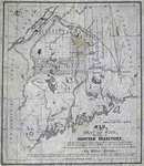
Taken from the Tate State survey the Public Lands in the State of Maine. The territory contains ten thousand seven hundred & five square miles, being two thousand nine hundred & five square miles or One Million eight hundred & fifty thousand, two hundred acres more than the whole State of Massachusetts.
Rights and Access Note
Rights assessment remains the responsibility of the researcher. No known restrictions on publication. For information about the process and fees for obtaining higher resolution scans or another file format, contact Special Collections.
Publication Date
1839
Publisher
T. Moore's Lithography
City
Boston, Massachusetts
Keywords
Maine Maps, New England Maps, Historic Maps, Regional Maps
Disciplines
United States History
Recommended Citation
Curtiss, Wilbur, "Map of the Seat of War showing the Disputed Territory and the Boundary lines claimed by Maine & Great Britain and that proposed by the King of the Netherlands" (1839). Maine Bicentennial. 115.
https://digitalcommons.library.umaine.edu/mainebicentennial/115
Included in
Rights Statement

Comments
MS_601_Box_2679_Folder_024